Trekking Through the Heart of the Cordillera Blanca
If you are looking for an incredible 3-4 day trekking adventure in Peru, this is it! The Santa Cruz Trek leads through two valleys connected by a 4750-meter pass in the heart of the Cordillera Blanca. Wildflower meadows with streams and herds of Lamas, mountain lakes, massive glaciers and sweeping views of incredible peaks, among them Alpamayo (called by some the most beautiful mountain in the world) and Artesonraju (the famous mountain in the Paramount Logo) – the Santa Cruz Trek has it all.

Sunrise view from our 2nd camp. The Santa Cruz Trek is one of the best things to do around Huaraz.
Quick Facts – Santa Cruz Trek
Stats: ca. 50km, ca. 3000m elevation gain, 3-4 days
Starting Point/End Point: Cashapampa or Colcabamba
Closest City: Huaraz (8 hours north of Lima)
Best Time to Go: May until Sep/Oct (depending on conditions and your gear)
Accomodation: None – Bring a tent and supplies or take a guided tour
Trekking in Peru is amazing, the best I have done so far. Treks are easily accessible, simple to navigate and quality gear, information, food and optionally guided tours or mule drivers are readily available in Huaraz, the mountaineering capital of the Andes and the hub for all activities in the Cordillera Blanca and the Cordillera Huayhuash. Huaraz is also the ideal base to get used to the altitude (at 3100m) and for an acclimatization hike, for example to Laguna Churup (4500m). My sister Eva, my brother Markus and I did the Santa Cruz Trek at the end of May, which I think is a great time, because we didn't see many other people the whole 4 days, while it can be pretty busy in the months after that, starting on the 1st of June. But beware it is still quite chilly at this time and temperatures easily drop to -5°C or -10°C at night. The Santa Cruz Trek can be started on both ends, either in Cashapampa or in Vaquería/Colcabamba. We did it from Cashapampa at the entrance of the Santa Cruz valley. The little village can be reached from Huaraz by taking a collectivo (mini bus) to Caraz and then changing to Cashapampa (3,5 hours). To go to Colcabamba, take a colectivo to Yungay and change to Vaquería/Colcabamba/Yanama there (at least 4,5 hours and less frequent). How can you navigate on the Santa Cruz Trek? Easy, the free offline map application “maps.me” shows the whole trail and possible campsites. At the trailhead you will probably be asked to buy the entrance ticket to Huascaran National Park for 65 soles (20 USD), if you haven’t already. It is valid for 21 days, so you might be able to take it from somebody who returns to Huaraz after a trek and doesn’t need it anymore. Don’t lose it, you’ll need it when you exit the park at the end of the trek.
Day 1: Hiking into Santa Cruz Valley (15km, 960m elevation gain)
While we drive into the tiny village of Cashapampa, we can already guess where our trek will begin. The mountains here form a wall that is hundreds of meters high and there is only one narrow gap, through which we will enter the Santa Cruz valley. Cashapampa is situated at 2900m, which is the lowest we have been in the last couple of weeks, after climbing several 5000m and one 6000m peak and so we start hiking swiftly even though our packs way about 18kg. Following the trail along a rambling river, we hike upwards, deeper into the narrow gorge, leaving civilization behind us for the next 4 days.

The adventure begins: Hiking into Santa Cruz Valley
We haven’t planned our first campsite yet, but there are a few potential spots in the valley and we want to cover a decent amount of distance despite getting a fairly late start. After about two hours of hard work, the trail slowly starts to even out and we get the first glimpses of the mountains that are towering left and right of the valley. We have our lunch on top of a big rock in a river bend, surrounded by confused cows who want to join us on the rock but then realize they cannot climb. The sun is shining, and we enjoy the luxury of fresh avocado and local cheese on our bread, what a good day 😉. At kilometer 9.5 we reach the camp Llamacorral, where a guided tour has set up camp, but we decide to go further. Continuing through the lush green valley we pass one more possible campsite at the far end of Laguna Ichiccocha. The sun has already disappeared behind the peaks of the Cordillera Blanca and so we decide to stay just a few hundred meters further at Laguna Jatuncocha. We find a beautiful camp spot right next to the water at the near end of the lake, set up the tent and cook our typical trekking dinner for Peru, Raman noodles with quinoa.

Our first campsite on the Santa Cruz Trek next to Laguna Jatuncocha.
It gets super cold during the night, but it is new moon and the skies are clear, there is no better time and place for shooting the stars. So when the alarm sounds at 1am in the morning, I force myself out of the comfort of my warm sleeping bag and go outside. The brightness and clarity of the milky way are breathtaking and so I spend more than half an hour experimenting with different settings and angles, while my fingers freeze off in the -10°C breeze. Afterwards I crawl back into my sleeping bag, cold but excited to have witnessed and captured this awesome night sky.

The heart of the Milky Way is clearly visible in the nightsky of Peru (ISO 12800; f 1,8; 8s)
Day 2: Alpamayo basecamp and Mirador Artesonraju (12,5km, 600m elevation gain)
When Markus leaves the tent, he is greeted by the first rays of the rising sun. Our oatmeal and fruit breakfast is super delicious – since the Santa Cruz Trek is "only" 4 days we decided to carry a few heavy bonus ingredients like apples, broccoli and avocados on this trip. We pack our stuff and continue up the valley. The landscape changes to a mostly dry river bed, at first deserted and then filled by bushes with blue and yellow blossoms. At this point we decide to take a side trip into a valley to the left, that leads to the basecamp for the famous Alpamayo (5947m) and when you turn around on the way up, you get the best views of the iconic Artesonraju (6025m) alias Paramount mountain right on the other side of the valley as well (maps.me also indicates the mirador). We hide our backpacks in a little forested area and hike up the steep switchbacks. When the path starts to flatten out into the Alpamayo valley we turn around to see Artesonraju – it is right there, huge and impressive but sadly the western half of it is covered by a stubborn cloud. We continue towards Alpamayo Base Camp for half an hour but the mountain tops above the glacier are completely stuck in clouds.
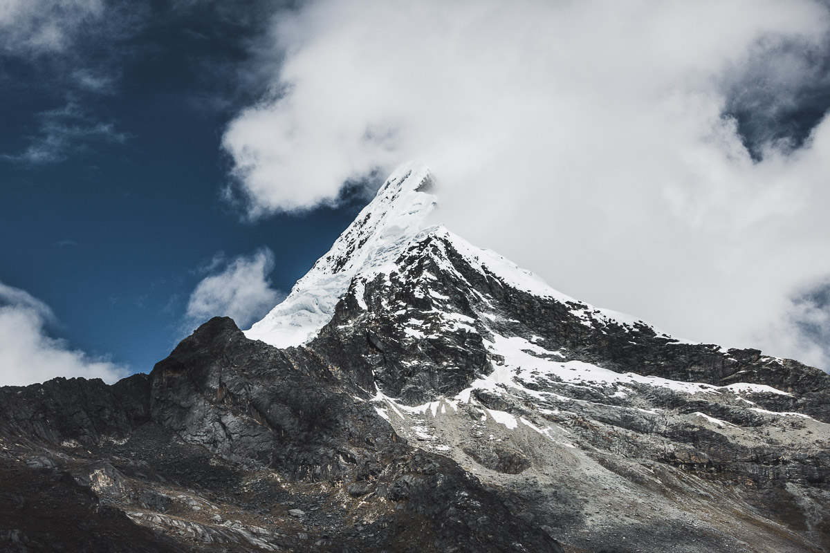
Artesonraju doesn't quite reveal itself to us.
We start going back a little frustrated that we did not see the alleged “most beautiful mountain in the world”. At this point there is a little path that crosses back over to the Santa Cruz Trek without loosing much elevation, but since we dropped our backpacks at the bottom of the switchbacks we have to go back down and follow the trail up from there. A little bit later we reach a big, open meadow known as the campsite Taullipampa with a river meandering through it. A guided tour has set up a few tents here. We walk along the meadow and cross the river. From here you can guess for the first time where the highest point of the Santa Cruz Trek, the pass Punta Union will be. It is not that late yet and we didn't cover a lot of distance, but since we brought enough food for four days we decide to just chill and stay in Taullipampa for the night. Plus, our chosen campsite will give us one more chance for a prime view of Alpamayo and Artesonraju in the morning. After a little exploration hike on one of the glacial moraines of Artesonraju, we cook and go to bed early, as it gets super cold once the sun is gone.
Day 3: To the Highest Pass of the Santa Cruz Trek – Punta Union (11km, 960m Elevation Gain)
We get up before sunrise to have a clear view in the cold morning air. In the Cordillera Blanca the first clouds often form on the highest peaks immediately as soon as the first sunrays hit. The views are perfect. Right from the tent we can see the massive Taulliraju towering above us.

Taulliraju from our camp. On the right, the highest pass of the Santa Cruz Trek – Punta Union.
Soon after that Artesonraju starts to glow in the first sunrays.

Alpenglow on Artesonraju – clouds immediately start to form around the summit.
We quickly hike up the moraine to get to a better viewpoint for Alpamayo as well. And there it is, Alpamayo and neighbouring Quitaraju are looking majestic with their almost vertical ribs of ice, emanating a white glow in the blue hour.

Quitaraju and Alpamayo just before sunrise
After breakfast we follow the path that starts to zig-zag upwards just behind the Taullipampa meadow. As we climb higher the view of the Santa Cruz Trek behind us gets better and better, but the wind also becomes stronger and temperatures drop. It takes quite a while to reach Punta Union, but finally we can see a small opening in a ridge, which leads into the next valley. We are glad to have made it to the highest point of the Santa Cruz Trek at a lofty 4750m, it’s all downhill from here – in a good way 😊.

Yes! On the pass with the completed half of the Santa Cruz Trek behind us.
After a little avocado snack and a chat with an exhausted German couple that arrives from the other side, we have to continue because we are getting cold. On the other side the view is equally beautiful and we quickly descend into a valley with little streams and lakes. Now we are about three times as fast and we are making quick progress down the long valley ahead of us.

Descending into Huaripampa valley from Punta Union
We pass several potential campsites until we arrive and set up camp at a place called Paria, a little meadow next to the river. I decide to climb up a very steep grassy slope for some nice evening views. Rain clouds suddenly start to form when I am already far above the valley. 5 minutes later it rains heavily, my pants are soaked in seconds and I scramble back down the slippery slope backwards on hands and feet. The most uncomfortable part is taking off the wet clothes while I am still outside the tent in the freezing cold. We have to cook from the inside, handling the stove through a little opening in the tent. The hot noodle soup feels like a deluxe meal and helps to warm up.
Day 4: From Paria to Vaquería and back to Huaraz (10km, 410m elevation gain)
In the morning it takes a while to get the tent at least half-dry, the sun is still hiding behind the clouds. Finally, we just pack up and start the last section of the Santa Cruz Trek. On the way we pass a swampy meadow with a bunch of different colored Lamas that don’t mind our company.

Lamas grasing in Quebrada Huaripampa
A few kilometers later we cross the border of Huascaran National Park. We talk to a few local villagers and their kids who are sitting at the side of the path knitting nice gloves and hats from soft Alpaca wool. After buying some hats as gifts and giving the kids candy we continue towards the first signs of civilization. After we hit the first road in Huaripampa, we turn right and face one more steep ascent to Vaquería. We read mixed reports on when the last bus to Huaraz comes through, but we hope to still catch one at 3pm or later. We arrive in the little village shortly before 3pm and celebrate the completion of the awesome Santa Cruz Trek with a beer. But our hopes that a bus will still be coming through are quickly shattered as locals tell us that the last bus from Vaquería to Huaraz comes through at about 1pm. The next bus is only between 1 and 2am in the morning. So we take a cheap room from the friendly locals who served us the beer and take the first bus back to Huaraz in the middle of the night.

The Santa Cruz Trek is beautiful. On top, the Ancash region offers many other cool things to do...
Beautiful things to do around Huaraz
We spent about 6 weeks in Huaraz and went mountaineering, trekking and rock climbing. The mountains certainly are among the most impressive in the world and there are so many places to explore. Although the region still only sees a small number of tourists compared to areas like Cusco and Arequipa, the Santa Cruz Trek is – together with the one-day hike to Laguna 69 – still the most popular thing to do here and well frequented in main season. If you are looking for even more off the beaten trek adventures or a more challenging experience, here are a few more places in the mountains around Huaraz: The 8-14 day Huayhuash Trek is unparalleled in beauty and wilderness. Hiking into Ishinca valley and staying at the awesome Refugio Ishinca opens up the possibility to climb the technically easy Urus (5420m), the moderate Ishinca (5530m) or the hard Tocllaraju (6032m). Three other amazing climbs around Huaraz we did are the Vallunaraju Peaks (5606m and 5686m), Pisco (5765m) and the mighty Chopicalqui (6354m). In the area of Cusco we probably invented a new route combining Rainbow Mountain with the Ausangate Trek in an awesome 5 day trek. I will write about all these other treks and climbs in Peru the future.
Please subscribe and like my Facebook page if you want to see the occasional new article and photos.
If you have questions about any of these or have done one of them yourself please let me know in the comments.
Full Gallery of the Santa Cruz Trek

VIEW FULL GALLERY
More pics and higher resolution!